


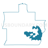
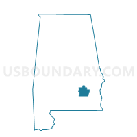
Brundidge-Haisten Building, Pike County, Alabama
About
Outline

Summary
| Unique Area Identifier | 522811 |
| Name | Brundidge-Haisten Building |
| County | Pike County |
| State | Alabama |
| Area (square miles) | 59.61 |
| Land Area (square miles) | 59.58 |
| Water Area (square miles) | 0.03 |
| % of Land Area | 99.95 |
| % of Water Area | 0.05 |
| Latitude of the Internal Point | 31.73148920 |
| Longtitude of the Internal Point | -85.79612270 |
Maps

Graphs
Select a template below for downloading or customizing gragh for Brundidge-Haisten Building, Pike County, Alabama


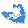


Neighbors
Neighoring Voting District (by Name) Neighboring Voting District on the Map
- Banks City Hall, Pike County, AL
- Enon-County Bldg, Pike County, AL
- Galloway Road Community Center, Pike County, AL
- Hamilton X Roads Hwy 231 S, Pike County, AL
- Josie-County Bldg, Pike County, AL
- M Pillar Church, Pike County, AL
- Park Memorial Church, Pike County, AL
- Springhill Housing Authority, Pike County, AL
- Sutton's Restaurant/Elamville Volunteer Fire Department, Barbour County, AL
- Tarentum Community Clubhouse, Pike County, AL
- Tennville Holder's Grocery, Pike County, AL
Top 10 Neighboring County Subdivision (by Population) Neighboring County Subdivision on the Map
- Troy CCD, Pike County, AL (20,070)
- Clio CCD, Barbour County, AL (4,303)
- Brundidge CCD, Pike County, AL (3,975)
- Henderson-Spring Hill CCD, Pike County, AL (2,753)
- Banks-Josie CCD, Pike County, AL (2,002)
- Louisville CCD, Barbour County, AL (1,638)
Top 10 Neighboring Place (by Population) Neighboring Place on the Map
Top 10 Neighboring Unified School District (by Population) Neighboring Unified School District on the Map
Top 10 Neighboring State Legislative District Lower Chamber (by Population) Neighboring State Legislative District Lower Chamber on the Map
Top 10 Neighboring State Legislative District Upper Chamber (by Population) Neighboring State Legislative District Upper Chamber on the Map
Top 10 Neighboring 111th Congressional District (by Population) Neighboring 111th Congressional District on the Map
Top 10 Neighboring Census Tract (by Population) Neighboring Census Tract on the Map
- Census Tract 1890, Pike County, AL (8,053)
- Census Tract 1891, Pike County, AL (7,023)
- Census Tract 9504, Barbour County, AL (4,303)
- Census Tract 1893, Pike County, AL (3,975)
- Census Tract 1892, Pike County, AL (2,753)
- Census Tract 1886, Pike County, AL (2,002)
- Census Tract 9503, Barbour County, AL (1,638)
Top 10 Neighboring 5-Digit ZIP Code Tabulation Area (by Population) Neighboring 5-Digit ZIP Code Tabulation Area on the Map
- 36081, AL (15,267)
- 36079, AL (9,339)
- 36010, AL (4,677)
- 36311, AL (2,770)
- 36005, AL (1,522)
- 36048, AL (1,459)